 |
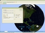 |
Authoring tool for GIS data preparation for online visualisation with BS Contact Geo.
Optimization for fast rendering of elevation models, vectors, point clouds and satellite image textures. Automatic triangulation and generation of tile and LOD structures.
Preparation of the data for online streaming at runtime and unlimited walkthroughs/flyovers e.g. in landscapes. GIS layers can be imported in the application developed.
Encryption on request with customizable GUI using BS Contact Geo and usage of computer server cluster via BS Geo Grid for acceleration of the application.
Product features:
- Automatic tile building and optimization for fast rendering of data derived from point clouds, models and imagery
- Import of elevation grid data, grid textures and vectors
- Import of ESRI *.shp-files
- Triangulation and tile building
- Automatic level of detail (LOD) optimization
- Data reduction
- Tile edge optimization
- Output texture formats: JPEG, JPEG 2000, PNG, TGA
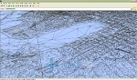 |  |  |
Example: Through the use of BS Tiler, 120 GB of earth image data have been reduced and optimized to 4 GB for the deployment on DVD and the Internet.
The landscape models that have been optimized with the BS Tiler can also be integrated as a component within the BS Contact Geo 3D Viewer in enduser applications.
Please download a test version from the Download Center.