 |
Given the many victims of the tsunami tidal wave in the year 2004 and the high property damage in South Asia or the floods in 2008, we can measure how high the damage could have hit cities and municipalities. It is not only the mega-disasters, their consequences - apart from the often unimaginably many victims - to such a large economic burden, but also the comparatively smaller but recurrent disasters such as flooding from snow melt in high regions, forest fires in the U.S. , Spain, Portugal or France, add to heavy balance sheet expenses. The goal must therefore be that the cost of disaster management should be limited, without neglecting people's lives.
The French software vendor EMI, Port de Bouc has developed a software tool, which should help quicker to recognize information for rapid and effective counter-measures, to collect and evacuate vulnerable people timely or faster and to save both the cost of damages manageable and therfor save the people. France is ravaged by massive forest fires year to year. Examples include the island of Corsica or the Côte d'Azur.
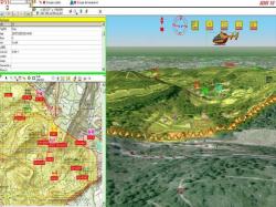
In such a crisis, a geographical information system (GIS) with interactive 3D visualization software extends to the developed program. This GIS is particularly suitable for providing information to save lives and limit the damage. Examples are the fight against major fires, floods, earthquakes and other crisis situations.
Moreover, such 3D software should ensure that the interactive application operating on real GIS data can be accessed. In the disaster program EMI, has therefore chosen the visualization software from Bitmanagement software. Depending on the current use of the graphical user interface it can be adapted to different situations.
The GIS tool is an integrated component of the 3D visualization software BS Contact VRML/X3D from Bitmanagement. It offers different features, such as interactivity, real-time and Internet capability. Moreover, with this 3D software live video can be re-fitted into the tool.
Since the majority of crisis situationsd the weather conditions are important weather such as wind direction and speed can be provided by the 3D software at realtime prepared from the current weather data. A crisis region can be mapped, and weather data can be used interactively in the process of intervention - thanks to the Internet capability of the software from Bitmanagement – It will be made available in Real Time at special Hotspots.
Real GIS data can also be simulated so that the GIS tool can rehearse virtual risk situations with additional training. In the worst case scenario the use of rescue forces and the use of better backups can then be prepared to coordinate and carry out successful dispatching. EMI already sells the civil protection tool to many French departments and companies, such as the extractive Industries.
Geographical information systems (GIS) are refined by the connection of interactive 3D visualization to an operatively usable program in the disaster control in the area of fire-fighting. The use of GIS and real weather data supports a faster, more efficient and coordinated deployment of rescue teams.
Used Viewer: BS Contact Geo