 |
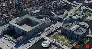
City models are usually created based on photos and textures done by hand and mapped on geometry. The manufacturing process of virtual models of cities and landscapes will be time-consuming, long and expensive. Now 3D models can be created automatically from textures of cities with a resolution of 4 inches per pixel in a few days to be visualized on the Internet with the BS Contact Geo viewer from Bitmanagement.
The result is a much better rendering quality, cheaper than the traditional manufacturing processes while greatly reducing the time needed. While conventional City Visualization Projects can devour hundred thousand of Euros, the cost for automatic data acquisition is substantially less.
3D City models can be integrated in a variety of applications - ranging from online search engines to navigation and entertainment systems in the automotive sector. With the new technology for example, a 3D model of an entire city with an area of approximately 200 square km can be created in only 4 days. The required data acquired i.e. raster and geometric data are created by cameras that are installed below an aircraft.
The 3D created automatically models are based on her Geo references which are integrated in the file format VRML/X3D or the exchange format Collada. The high qualitaty models which are provided by Bitmanagement content partners are finally optimized with Bitmanagement tools for the visualization on the Internet.
By using BS Tiler, for spatial data processing for example for the flight-over functionality and the functional node X3D Geo, that is supported in BS Contact Geo, the result can be viewed interactively and can be navigated on the platforms of Microsoft, Linux and Apple (alpha). The integration of VRML/X3D or CityGML house models provided by leading Geo content providers enhance the 3D experience, because the user can surf in city models down to street level and can see buildings such as museums, city halls or football stadiums even from inside.
The visualisation of 3D city models created in the old fashioned style is supported in BS Contact Geo, too.
Used Viewer: BS Contact Geo
More Information: Whitepaper GIS-Visualisation (PDF)
Reference: www.moss.de